WreckSight is the 3DVisLab’s interactive application for viewing subsea 3D data and was originally developed from 2008 in partnership with ADUS (Advanced Underwater Surveys Ltd) for industrial use. This Web app version, which is based on the open source Potree point cloud renderer, now brings subsea 3D visualisation to a wider audience.
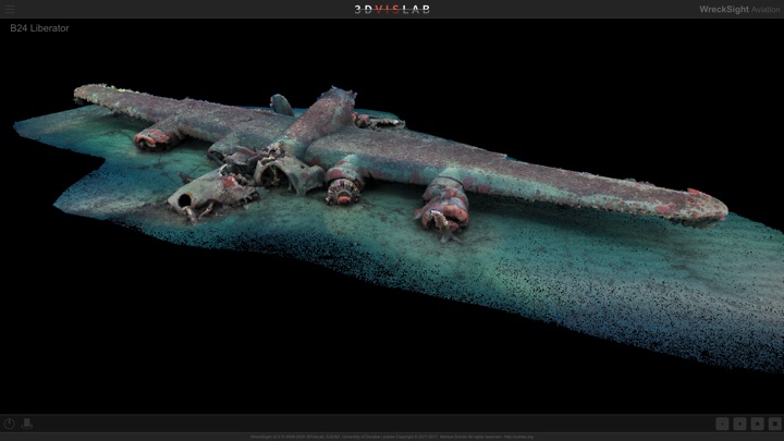
Two WreckSight editions are currently available: WreckSight Scapa Flow is based on a 2006 multibeam sonar survey by ADUS, and WreckSight Aviation features WWII aircraft wrecks from the Maltese archipelago - this data was acquired in 2017 by Chris Rowland and colleagues using photogrammetry techniques resulting in vivid full colour imagery. Click the links below to access the Web apps.
These downloads provide examples of how we use Augmented Reality content as part of our Subsea Visualisation research. The examples include a section of an exhibition panel and an extract of a popup book. You can download these and view the AR content using the free Zappar app for Android or iPhone. Search for "Zappar" on your App Store. To download the examples right-click on the link and choose to save to your computer.
Chris Rowland and John Anderson began collaborating with Martin Dean and Mark Lawrence of ADUS (Advanced Underwater Surveys Ltd) on WreckSight in 2008 with the aim of creating an accessible and interactive 3D platform for ADUS subsea data.
The idea of WreckSight originated in the PhD research of Chris Rowland who developed a method for the aesthetically considered 3D representation of subsea multibeam sonar data. Dissatisfied with the readability of the prevailing imaging methods of the time, Chis Rowland established a number of innovations that significantly enhanced the usefulness of subsea 3D data, particularly for non-specialist audiences. John Anderson subsequently developed the first interactive version of WreckSight using the C programming language and OpenGL and designed and implemented the supporting workflow that enabled the application to be used in industry.
WreckSight has had significant impact in several contexts including as a visual briefing tool for recreational diving, a visualisation and planning aid in marine salvage and as an interactive platform for public engagement with marine heritage research projects. WreckSight has been extensively utilised in several high profile and large scale marine salvage operations and accident investigations including: subsea visualisation of the Deepwater Horizon disaster in the Gulf of Mexico (2010), preparations for the parbuckling of the cruise liner Costa Concordia at Giglio, Italy (2013), visualisation of the wreck of the South Korean passenger ferry SEWOL (2014) and time series visualisations of the wreck removal process for the container vessel MV Rena from Astrolabe Reef, Bay of Plenty, New Zealand (2012 – 2015).
Notable heritage-related ADUS surveys that have been visualised with WreckSight include HMS Royal Oak, the German High Seas Fleet at Scapa Flow and the Battle of the Atlantic wrecks, commissioned by NOAA.
3D multibeam sonar survey data provided by and used by kind permission of ADUS/ADUS DeepOcean.
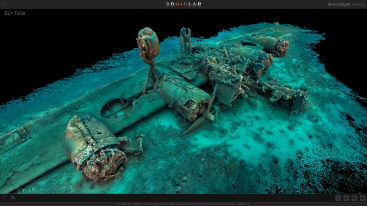
B24 Tulsa
Survey Data: University of Malta and University of Dundee, 2017
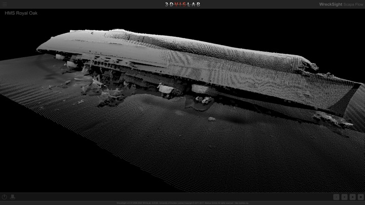
HMS Royal Oak
Survey Data: ADUS, 2006
Rowland, C & Anderson, J 2010, WreckSight: revealing our submerged maritime heritage. In VAST 2010: The 11th International Symposium on Virtual Reality, Archaeology, and Cultural Heritage. VAST'10, Eurographics Association, pp. 39-45, International Symposium on Virtual Reality, Archaeology and Intelligent Cultural Heritage, Paris, France, 21/09/10.
Read More